


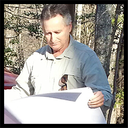
 Roger Morgan(owner) has over 30 years of land surveying experience in
airport approach, boundary, topographic, construction, road and
utility route surveys and bridge inspections with over twenty years
managing multiple crews on various projects. He has been a resident
of Burke County for about two decades.
Roger Morgan(owner) has over 30 years of land surveying experience in
airport approach, boundary, topographic, construction, road and
utility route surveys and bridge inspections with over twenty years
managing multiple crews on various projects. He has been a resident
of Burke County for about two decades.
Facts You Should Know About Having Your Land Surveyed
When Is A Survey Usually Required?
Before title to land is conveyed, it is desirable to have an adequate description of the property for the deed, including an accurate determination of the acreage. It is also important to know if there are any physical features or title overlaps, which might constitute encroachment s or, in some way, adversely affect the title to the land. Only an up to date survey, by a Professional Land Surveyor , can give you this information.
Most North Carolina cities and counties have subdivision ordinance procedures, which must be followed. For any subdivision, the Professional Land Surveyor can work with you to prepare the required maps. This may be a simple procedure, but may, depending on the situation, involve any of the following: a boundary survey, a topographical survey, site analysis, road and lot layout, road grade design, and the calculations for the necessary erosion control features. The Professional Land Surveyor can also prepare the subdivision plat for recording, the road plan and profile maps, and the erosion control plans.
The Professional Land Surveyor can explain the requirements of the local Subdivision Ordinance and assist you in getting the necessary approvals for your development.
Before land is improved by constructing drives, fences, walls, or buildings, it is desirable to know the location of the property corners and boundaries. Using the services of a Professional Land Surveyor, for staking and grading the locations of the improvements, avoids encroachments upon adjoining property and possible litigation at a later date. It also ensures the improvements will be constructed according to the design plans.
Before land is partitioned by a will or by Court Order, a survey of the land is needed. In the case of a will, the boundary of the property as well as the improvements, such as buildings, roads, and drives, on the property need to be located. When the land is divided, the heirs can easily decide on the location of the new dividing lines. Also, before the court can establish a disputed boundary line, it needs an accurate survey of the land. The Professional Land Surveyor can provide the necessary maps.
When a question arises as to the location of a boundary line between you and your neighbor, the first thing you need to do is get an accurate boundary survey. When the survey is completed, the Professional Land Surveyor can explain the location of the boundary line. In some cases, the surveyor can help solve the problem between you and your neighbor; at other times, the surveyor will appear in court as an expert witness on your behalf.
Selecting A Professional Land Surveyor
When it is determined that a land survey is needed, only a Professional Land Surveyor , licensed by the North Carolina State Board of Registration for Professional Engineers and Land Surveyors, is legally permitted to survey the land in North Carolina.
Every Professional Land Surveyor must follow the requirements listed in the "Standards of Practice for Land Surveying in North Carolina". The State Board publishes these standards and the Professional Land Surveyor you hire can provide you a copy upon request. The Standards of Practice lists everything the land surveyor must do during a survey and what must appear on the final survey map.
It is best to select a Professional Land Surveyor by qualifications. A well-qualified land surveyor will take the time to ask you about your needs for the survey. The surveyor will then explain what is required to complete your survey, and will answer all of your questions in a helpful manner so that you understand the process.
The Professional Land Surveyor constantly updates field equipment and office computers in order to provide you with the best service.
If you needed heart surgery, would you select the cheapest or the best surgeon? The same principle applies when selecting a Professional Land Surveyor . Remember, many times, the "cheapest" survey has the most cost in additional surveying and legal fees.
Types Of Surveys
Boundary Survey:
A Boundary Survey is a survey of the boundary of property according to the description
in the recorded deed. Interior improvements such as buildings, drives, etc., are not located.
Any improvements along the boundary affecting the use of or title to the property are located
such as fences, drives, utilities, buildings, sheds, streets, etc. Missing corner markers are
replaced. A map showing the boundaries and improvements along the boundaries is prepared.
Location Survey:
A Location Survey is a boundary survey with the additional location of all the interior
improvements. Missing corner markers are replaced. A map showing the boundaries and
improvements along the boundaries is prepared. This type of survey is required for the
acquisition of a loan.
Topographic Survey:
A Topographic Survey is a survey locating all improvements and topographic features such
as: elevations of the land, embankments, contours, trees, water courses, roads, ditches,
utilities, etc. This survey can be used in conjunction with a Location Survey in order to
prepare a Site Design Map, a Subdivision Map, or an Erosion Control Plan.
Site Planning Survey:
This survey uses a boundary and topographic survey as a base to design future
improvements. It can be a design for a house, a residential subdivision, a store, a
shopping center, a new street or highway, a playground, or anything else.
Subdivision Survey:
This often includes a topographic survey of a parcel of land, which will be divided into
two or more smaller tracts, lots, or estate division. This can also be used for site design of
lots, streets and drainage.
Construction Survey:
A Construction Survey uses surveying techniques to stake out buildings, roads, walls,
utilities, etc. This includes horizontal and vertical grading, slope staking, and final
as-built surveys.
Geographic Positioning System:
GPS surveys use portable receiving antennas to gather data transmitted from satellites,
which are used to calculate the position of the object being located on the surface of the
earth. The receiving antennas can be miles apart and still obtain very accurate data. This is
being used to establish coordinate control points for State Plane Coordinate Systems, large
boundary surveys, and subdivision surveys. It can also be used to collect data for Geographic
Information Systems / Land Development Systems (GIS/LDS), such as the location of streets,
homes, businesses, electric and phone lines, gas lines, water & sewer systems, property
lines, soil and vegetation types, water courses, etc. This data can be used in future planning,
preservation and development.
ALTA/ACSM Survey:
This survey is a very detailed survey often required by lending institutions.
The request for this survey must be in writing and be accompanied by all of the deeds
and easements affecting the subject property, as well as the deeds to adjoining properties.
A list of items to be located as noted in the ALTA/ACSM publication can also be included.
What the Professional Land Surveyor needs from you
The Professional Land Surveyor needs: Your name, current address and phone number, and the name of the current owner of the land. Other information that will be helpful is the Parcel Identification Number (PIN) of the property, and the Deed Book and Page Number of the current deed. Also, any deeds, wills, or maps that you may have will be helpful.
It is not necessary for you to search for or get copies of the neighbors' deeds. The Professional Land Surveyor is an expert at this research and is required to do this by the Standards of Practice.
The information you submit to the Professional Land Surveyor can be mailed. This is preferred because it gives written authorization to proceed. A retainer may be required for certain surveys before the land surveyor will begin your survey.
Why Survey Costs Vary
The Professional Land Surveyor 's fee will include the time to search for deeds or court records, locate the physical boundary evidence at the property, make the necessary computations to check the boundary, place appropriate markers on the property, and prepare the survey map.
The cost of the survey will vary because of missing corner evidence, disputed boundary lines, rough terrain, heavy underbrush, poor land descriptions in the deeds, and travel time to and from the property.
Because of varying conditions, it is difficult for the Professional Land Surveyor to predict an exact cost. The same conditions and the number of jobs pending will affect when your survey can be completed. This time can vary from days to months.
Additional Information
A survey is a highly technical and complex service utilizing the art of measuring, mathematics, and the proper interpretation of real property law.
A title insurance policy is generally issued when property is purchased. This covers the title of the property to protect the owner, or the loan to protect the lender. It can also cover the survey if specified. Discuss the provisions of title insurance with your lawyer.
The Professional Land Surveyor can survey your land only according to the deeds and other available information. The location of the boundary lines marked by the surveyor is only a professional opinion based on the evidence found in the records and on the ground. However, the accuracy by which the Professional Land Surveyor accomplishes this service is backed by his professional integrity.
In today's business world, lawyers, engineers, and architects rely heavily on the Professional Land Surveyor's integrity and accuracy.
In case of litigation, the Professional Land Surveyor will appear in court as an expert witness. The surveyor's testimony is accepted as professional evidence by the court.